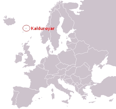
Kalduroyar
From Confederacy
Nihonkaranws (Talk | contribs) (→Administrative divisions) |
(made municipial weapons - thumbnail links from Wikipedia) |
||
| Line 43: | Line 43: | ||
* http://www.midt-troms.no/getfile.php/364266.1048.xytcsrtwbw/berg.gif Fjørðoy sýsla | * http://www.midt-troms.no/getfile.php/364266.1048.xytcsrtwbw/berg.gif Fjørðoy sýsla | ||
| - | ** Vágar kommuna | + | ** http://upload.wikimedia.org/wikipedia/commons/thumb/9/99/Salangen_komm.png/18px-Salangen_komm.png Vágar kommuna |
| - | ** Vesturhavnar kommuna | + | ** http://upload.wikimedia.org/wikipedia/commons/thumb/9/99/Ibestad_komm.png/18px-Ibestad_komm.png Vesturhavnar kommuna |
| - | ** Suðurfjall kommuna | + | ** http://upload.wikimedia.org/wikipedia/commons/thumb/9/99/Kvanangen_komm.png/18px-Kvanangen_komm.png Suðurfjall kommuna |
| - | ** Norðvágar kommuna | + | ** http://upload.wikimedia.org/wikipedia/commons/thumb/9/99/Storfjord_komm.png/18px-Storfjord_komm.png Norðvágar kommuna |
| - | ** Brattnes kommuna | + | ** http://upload.wikimedia.org/wikipedia/commons/thumb/9/99/Skanland_komm.png/18px-Skanland_komm.png Brattnes kommuna |
| - | ** Brattbøur kommuna | + | ** http://upload.wikimedia.org/wikipedia/commons/thumb/9/99/Bjarkoy_komm.png/18px-Bjarkoy_komm.png Brattbøur kommuna |
* http://www.midt-troms.no/getfile.php/364263.1048.tqssasvxaf/torsken.gif Nólsoy sýsla | * http://www.midt-troms.no/getfile.php/364263.1048.tqssasvxaf/torsken.gif Nólsoy sýsla | ||
| - | ** Norð-Nólsoy kommuna | + | ** http://upload.wikimedia.org/wikipedia/commons/thumb/9/99/Balsfjord_komm.png/18px-Balsfjord_komm.png Norð-Nólsoy kommuna |
| - | ** Suður-Nólsoy kommuna | + | ** http://upload.wikimedia.org/wikipedia/commons/thumb/9/99/Verran_komm.png/18px-Verran_komm.png Suður-Nólsoy kommuna |
* http://www.midt-troms.no/getfile.php/364267.1048.uuvacveybb/dyroy.gif Vindioyggjar sýsla | * http://www.midt-troms.no/getfile.php/364267.1048.uuvacveybb/dyroy.gif Vindioyggjar sýsla | ||
| - | ** Skálavík kommuna | + | ** http://upload.wikimedia.org/wikipedia/commons/thumb/9/99/Verdal_komm.png/18px-Verdal_komm.png Skálavík kommuna |
| - | ** Gøtu kommuna | + | ** http://upload.wikimedia.org/wikipedia/commons/thumb/9/99/Lenvik_komm.png/18px-Lenvik_komm.png Gøtu kommuna |
| - | * http:// | + | * http://upload.wikimedia.org/wikipedia/commons/thumb/9/99/Skjervoy_komm.png/18px-Skjervoy_komm.png Eysturoyggjar sýsla |
| - | ** Norð-Viðoy kommuna | + | ** http://upload.wikimedia.org/wikipedia/commons/thumb/9/99/Karlsoy_komm.png/18px-Karlsoy_komm.png Norð-Viðoy kommuna |
| - | ** Suður-Viðoy kommuna | + | ** http://upload.wikimedia.org/wikipedia/commons/thumb/9/99/Gratangen_komm.png/18px-Gratangen_komm.png Suður-Viðoy kommuna |
* http://www.midt-troms.no/getfile.php/364261.1048.saawqauveb/malselv.gif Borðoy sýsla | * http://www.midt-troms.no/getfile.php/364261.1048.saawqauveb/malselv.gif Borðoy sýsla | ||
Revision as of 01:02, 16 March 2008
| ||||
| Demonym | Kalduroyan, Kalduroyans | |||
| Population | ~ 40.000 | |||
| Capital | Vesturhavnar | |||
| Language | Faroese | |||
| Government - President - Prime Minister - Largest political party - Cabinet | Republic Jákup Dahl (SF) Eyðun Fjallsvík (FF) Fólkaflokkurin (FF) Right-wing | |||
| National anthem | Mítt land | |||
| Currency | Kalduroyan króna (KAK) | |||
| Top-level domain (TLD) | .ka | |||
| National symbols • Animal • Flower | Atlantic Puffin (Fratercula arctica) Calluna (Calluna vulgaris) | |||

| ||||
|---|---|---|---|---|
Republic of Kalduroyar, Kalduroyar in daily speech, is perhaps the smallest member nation of COFR with the tiny population of 40.000. Between the middle age and 1857, Kalduroyar was under Danish jurisdiction. The most of the Kalduroyan culture, including the language, is brought from the Faroe Islands. The current president, Jákup Dahl, was elected in 2002 (and re-elected in 2006).
Geography
Kalduroyar consists of seven different islands, where Fjørðoy is the largest, and Lítla Dimun is the smallest. Most of the Kalduroyans live in small villages (bygðar) around in the archipelago.
The islands were created by volcanoes hundreds of thousands of years ago, and there's a lot of wind. The ground consists mainly of volcanic mountains and rocks with a thin layer of dirt upon it. Many places (especially at tall peaks and steeps) there isn't dirt at all. Places like that don't give any basis for human settlement, so therefore, most of the villages are located in small valleys innermost in the numerous fjords. Other villages are located near the sea (to have easier acession to the fish resources off-shore), but these villages are located at places without much wind (often with surrounding mountains).
Administrative Divisions
Each island is its own administrative division, which is called a sýsla (plural; sýslar, can be translated to county). The counties Fjørðoy, Nólsoy and Viðoy are also divided into additional administrative units called kommunar (which can be translated to municipality). Vindioy, Gøtu and Lítla Dimun were unified in one single county in 1992; Vindioyggjar. The smallest unit is Brattbøur kommuna in Fjørðoy sýsla.
These are the administrative divisions of Kalduroyar:
-
 Fjørðoy sýsla
-
 Vágar kommuna
-
 Vesturhavnar kommuna
-
 Suðurfjall kommuna
-
 Norðvágar kommuna
-
 Brattnes kommuna
-
 Brattbøur kommuna
-
-
 Nólsoy sýsla
-
 Norð-Nólsoy kommuna
-
 Suður-Nólsoy kommuna
-
-
 Vindioyggjar sýsla
-
 Skálavík kommuna
-
 Gøtu kommuna
-
-
 Eysturoyggjar sýsla
-
 Norð-Viðoy kommuna
-
 Suður-Viðoy kommuna
-
-
 Borðoy sýsla

