Sea level
From Wikiteer
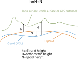
Sea level, aka mean sea level, is the average height of the sea. This concept is extended throughout the globe by an equipotential closed surface called the geoid. The geoid is irregular in shape. It is not a sphere, and in fact it is not even a spheroid.

Sea level is constantly changing, due to tides, waves, and other complications, and in fact the mean sea level in any particular area is not the same. For instance, mean sea level at the Pacific end of the Panama Canal stands 20 cm higher than at the Atlantic end, and if the Panama Canal was open sea and not locks (i.e. if somehow a deep open cutting had been made rather than the canal system over the mountains) then there would be a current flowing from Pacific to Atlantic.