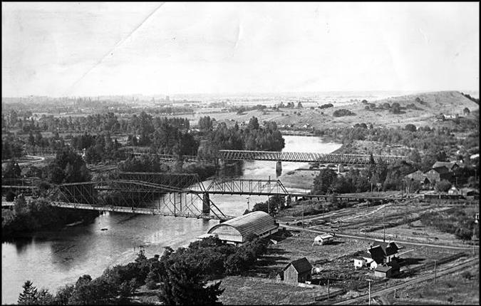
Springfield Main Street Bridge
From Lane Co Oregon
1870s
- The Briggs Ferry continued operation until 1875, at which time a covered bridge was constructed across the Willamette River. The wooden span was 368 feet long and was built by public conscription and county funds (Walling 1884:453).
A covered bridge, it was built with what were known as “Smith trusses,” invented just seven years earlier by Robert W. Smith of Tippecanoe, Ohio, and considered stronger and safer than any other bridge designs then in use.
“Truss” refers to the strengthening of a framework by using the rigidity of the triangle.
“The Smith truss inspires trust,” a newspaper commentator asserted in the Lane County Historian.
The contract to build the bridge was awarded to Albert Stuart Miller, also of Ohio, who had purchased the rights to construct Smith truss bridges in both Oregon and the Washington Territory. A.S. Miller & Sons relocated to Springfield in May 1874, and by Sept. 10 it had completed the bridge. The cost was $5,300.
For the next seven years, wagons, stock and pedestrians used the bridge daily. Then came the flood of 1881, though it wasn’t the raging waters that felled the bridge. A large tree caught in the current struck one of the wooden supports. The bridge “just dropped into the swirling, muddy water and floated off downstream,” an eyewitness reported.
Anyone crossing the bridge at the time would have endured a dramatic, four-mile float downstream before the bridge came to rest. Fortunately, the bridge was not in use when the tree took out the support.
1880s
The bridge was flooded out and replaced in 1881. The new structure featured a Smith truss bracing system and 220-foot span (Special Collections n.d.: Box 66-20, Folder 7A/B).
Miller was hired a second time, and once again the chosen design was a covered bridge made entirely of wood. This time, however, the cost was a whopping $14,275 and the result was a landmark.
“The Springfield Bridge is an immense structure towering as high as the trees around it,” crowed the local paper. “When it receives its roof it will be visible from a great distance on either side of the river.”
The paper went on to make the confident prediction that only a second deluge or the end of the world would take out this bridge. When it was destroyed within the decade by yet another flood, the disaster spelled the end of wooden bridges and of Miller’s involvement.
Like the Titanic, the 1881 Springfield bridge over the Willamette River was expected to last forever. In the words of a local newspaper at the time, “When a flood comes high enough to take that bridge away, it will be either a second deluge or the end of the world.”
Nine years later the bridge was gone, destroyed by a flood that put downtown Springfield under four feet of water.
1890s
During the summer of 1890 Wm. H. Dall collected at several of these Miocene localities, and by the assistance of Prof. Condon has been able to note a wider distribution of the Eocene than has heretofore been recognized in this State.
Miocene rocks are well exposed at Smith's quarry, 1 mile east of Eugene City, and at Springfield bridge, 2 miles farther east. At the former locality the rocks consist of grayish hard sandstone weathering to a yellowish color, irregularly bedded above, but massive below, dipping about 6° southeast, with a total exposure of about 37 feet. The fossils—Mytilus, Modiola, Mactra, Solen, Natica, Neverita, Purpura, and Lirofusus—are crowded or crushed together along certain lines or layers, and are usually in form of molds recrystallized into spar. The second locality, or that near Springfield, affords an excellent exposure of nearly a mile in length, extending southward from the abutment of the new bridge. The rocks have an easterly dip of from 5° to 8° and form a total perpendicular exposure of about 160 feet; they are overlain unconformably by 5 or 10 feet of alluvial matter which lies on their eroded edges. In the hilly regions, according to the observations of Prof. Condon, they are capped with basalt.
Harris, Gilbert Dennison and William Healey Dall. Correlation Papers: Neocene. Washington: Government Printing Office, 1892. p. 227.
To build the current double span over the Willamette between Springfield and Glenwood would take 84 years, and involve five projects and four construction companies.
The new Springfield bridge took 120 working days to build, cost $30,000, and employed a design calling for three 200-foot trusses supported on concrete piers. This bridge spanned more than the river — it carried the thirsty from “dry” Eugene to the saloons of Springfield by electric streetcar.
The streetcar ceased operation in the mid-1920s. In 1929, the bridge was converted to automobile use, which continues to this day. A companion bridge, built to handle the increasing flow of city traffic, was completed in 1958. The bridges now carry more than 12,900 cars a day heading west, and 14,100 a day traveling east.
Ongoing maintenance is now the major expense for the Springfield bridges, but the most costly problem is no longer the wild water that flows beneath them — it may be the homeless people who sleep under them.
Over the past decade (1999 to 2008), the state has spent roughly $100,000 on cleaning up the camps of transients who seek shelter below the bridges.
“It’s public land and we can’t go in and kick them off, but there is a no camping ordinance, so we clean up whatever has been left,” said Joe Harwood of the Oregon Department of Transportation. Rather than continue to clean out the camps every three months, the department hopes to get the necessary permits to “cage in” the spaces between the underside of the bridges and the riverbanks by June.

