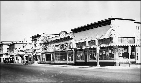
Main Street (Springfield)
From Lane Co Oregon
(Difference between revisions)
(→1940s) |
|||
| Line 1: | Line 1: | ||
{{Main Header}} | {{Main Header}} | ||
| - | =1850s= | + | =Timeline= |
| + | ==1850s== | ||
*According to an article in the [[Eugene Register]] dated July 4, [[1891]], the first store was opened in [[1852]] by [[Huddleston, James|James Huddleston]] on the east bank of the [[Willamette River]] as a trading post in [[Springfield]], near [[Mill Street_(Springfield)|Mill]] and [[Main Street_(Springfield)|Main Street]]. | *According to an article in the [[Eugene Register]] dated July 4, [[1891]], the first store was opened in [[1852]] by [[Huddleston, James|James Huddleston]] on the east bank of the [[Willamette River]] as a trading post in [[Springfield]], near [[Mill Street_(Springfield)|Mill]] and [[Main Street_(Springfield)|Main Street]]. | ||
| Line 9: | Line 10: | ||
*[[Springfield]] was platted in [[1856]], at which time two blocks between [[South A Street (Springfield)|South A]], [[Main Street (Springfield)|Main]], [[Mill Street (Springfield)|Mill]], and [[3rd Street (Springfield)|Third Street]]s were laid out into eight lots each. The lots measured 66x120 feet, with streets 66 feet in width and alleys 14 feet wide. Though the town was oriented to the [[Willamette River]], it developed along a standard grid system that was aligned to the four cardinal directions. | *[[Springfield]] was platted in [[1856]], at which time two blocks between [[South A Street (Springfield)|South A]], [[Main Street (Springfield)|Main]], [[Mill Street (Springfield)|Mill]], and [[3rd Street (Springfield)|Third Street]]s were laid out into eight lots each. The lots measured 66x120 feet, with streets 66 feet in width and alleys 14 feet wide. Though the town was oriented to the [[Willamette River]], it developed along a standard grid system that was aligned to the four cardinal directions. | ||
| - | =1940s= | + | ==1940s== |
*Signaling the development that was to come along [[Main Street (Springfield)|Main Street]] eastward toward [[Thurston area|Thurston]], the [[Paramount Market]] opened its new “supermarket” at the corner of Main and [[21st Street (Springfield)|21st Street]] in March [[1945]] launching what would become the [[Paramount commercial district]] ([[Springfield News]] 1943, 1945) | *Signaling the development that was to come along [[Main Street (Springfield)|Main Street]] eastward toward [[Thurston area|Thurston]], the [[Paramount Market]] opened its new “supermarket” at the corner of Main and [[21st Street (Springfield)|21st Street]] in March [[1945]] launching what would become the [[Paramount commercial district]] ([[Springfield News]] 1943, 1945) | ||
| Line 17: | Line 18: | ||
*Springfield sought a new post office in [[1947]], but was not approved for a new facility until [[1949]], when a new concrete building was constructed on [[Main Street (Springfield)|Main]] at [[6th Street (Springfield)|6th]] for the new office. | *Springfield sought a new post office in [[1947]], but was not approved for a new facility until [[1949]], when a new concrete building was constructed on [[Main Street (Springfield)|Main]] at [[6th Street (Springfield)|6th]] for the new office. | ||
| - | =1950s= | + | ==1950s== |
*A new [[Dairy Queen]] opened on [[Main Street (Springfield)|Main]] between [[8th Street (Springfield)|8th]] and [[9th Street (Springfield)|9th Streets]] in [[1951]]. | *A new [[Dairy Queen]] opened on [[Main Street (Springfield)|Main]] between [[8th Street (Springfield)|8th]] and [[9th Street (Springfield)|9th Streets]] in [[1951]]. | ||
| + | |||
| + | =Location= | ||
| + | |||
| + | ==Mill Street== | ||
| + | |||
| + | ==2nd Street== | ||
| + | |||
| + | ==[[6th Street (Springfield)|6th Street]]== | ||
| + | |||
| + | Post office was constructed on [[Main Street (Springfield)|Main]] at [[6th Street (Springfield)|6th]] in [[1949]]. | ||
| + | |||
| + | |||
| + | ==[[8th Street (Springfield)|8th Street]]== | ||
| + | |||
| + | [[Dairy Queen]] opened between [[8th Street (Springfield)|8th]] and [[9th Street (Springfield)|9th Streets]] in [[1951]] | ||
| + | |||
[[Category:Springfield]] [[Category:Springfield Beacon]] [[Category:Springfield roads]] [[Category:Main Street_(Springfield)]] | [[Category:Springfield]] [[Category:Springfield Beacon]] [[Category:Springfield roads]] [[Category:Main Street_(Springfield)]] | ||
Revision as of 23:53, 27 September 2007
Locations · People · Equipment · Chronology · Index · Categories · Browse · Discussion · FAQ · Help · Things to do · Article requests
Contents |
Timeline
1850s
- According to an article in the Eugene Register dated July 4, 1891, the first store was opened in 1852 by James Huddleston on the east bank of the Willamette River as a trading post in Springfield, near Mill and Main Street.
- In 1853, a small trading post was kept by J.N. Donalds near the corner of present-day Mill and Main Streets (Walling 1884:452).
- Springfield was platted in 1856, at which time two blocks between South A, Main, Mill, and Third Streets were laid out into eight lots each. The lots measured 66x120 feet, with streets 66 feet in width and alleys 14 feet wide. Though the town was oriented to the Willamette River, it developed along a standard grid system that was aligned to the four cardinal directions.
1940s
- Signaling the development that was to come along Main Street eastward toward Thurston, the Paramount Market opened its new “supermarket” at the corner of Main and 21st Street in March 1945 launching what would become the Paramount commercial district (Springfield News 1943, 1945)
- Springfield sought a new post office in 1947, but was not approved for a new facility until 1949, when a new concrete building was constructed on Main at 6th for the new office.
1950s
- A new Dairy Queen opened on Main between 8th and 9th Streets in 1951.
Location
Mill Street
2nd Street
6th Street
Post office was constructed on Main at 6th in 1949.
8th Street
Dairy Queen opened between 8th and 9th Streets in 1951

