The Setting
From Ars Magica
(→The County of Shropshire) |
m (→Where are we?) |
||
| Line 8: | Line 8: | ||
Little Stretton, Church Stretton, and All Stretton, are three small settlements that form the manor of Stretton-en-le-Dale. The central and largest settlement, where the church was built, is the small market town of Church Stretton, some 19 km. south-southwest of Shrewsbury and 20 km. north-north-west of Ludlow. The village is dominated by the huge Long Mynd massif, which provides Church Stretton with both its views, and good, fresh spring water. | Little Stretton, Church Stretton, and All Stretton, are three small settlements that form the manor of Stretton-en-le-Dale. The central and largest settlement, where the church was built, is the small market town of Church Stretton, some 19 km. south-southwest of Shrewsbury and 20 km. north-north-west of Ludlow. The village is dominated by the huge Long Mynd massif, which provides Church Stretton with both its views, and good, fresh spring water. | ||
| - | All the settlements lie near, but not on, the Roman road from Deva (Chester) via Viroconium Cornoviorum (Wroxeter) to Isca (Caerleon, Mon.) The road, itself known as Botte (Bot) Street, gave a name to the three Strettons, | + | All the settlements lie near, but not on, the Roman road from Deva (Chester) via Viroconium Cornoviorum (Wroxeter) to Isca (Caerleon, Mon.) The road, itself known as Botte (Bot) Street, gave a name to the three Strettons, All Stretton apparently taking its particular name from one Alfred, the nature of whose connection with the settlement is not known. |
Between Little Stretton and Church Stretton lies Brockhurst Hill, upon which a modest castle has been newly constructed to watch over the roman road. | Between Little Stretton and Church Stretton lies Brockhurst Hill, upon which a modest castle has been newly constructed to watch over the roman road. | ||
Revision as of 09:37, 5 February 2006
Contents |
Where are we?
The game begins with the players and their retinue arriving at an inn in the small village of Little Stretton.
Little Stretton, Church Stretton, and All Stretton, are three small settlements that form the manor of Stretton-en-le-Dale. The central and largest settlement, where the church was built, is the small market town of Church Stretton, some 19 km. south-southwest of Shrewsbury and 20 km. north-north-west of Ludlow. The village is dominated by the huge Long Mynd massif, which provides Church Stretton with both its views, and good, fresh spring water.
All the settlements lie near, but not on, the Roman road from Deva (Chester) via Viroconium Cornoviorum (Wroxeter) to Isca (Caerleon, Mon.) The road, itself known as Botte (Bot) Street, gave a name to the three Strettons, All Stretton apparently taking its particular name from one Alfred, the nature of whose connection with the settlement is not known.
Between Little Stretton and Church Stretton lies Brockhurst Hill, upon which a modest castle has been newly constructed to watch over the roman road.
The Long Mynd, or 'Long Mountain', is a ridge of high ground in South Shropshire, running roughly SW to NE, and extending some 15 km in length, between the Stiperstones to the west, and Wenlock Edge to the east. The rock is pre-Cambrian, though not as old as the volcanic rock of the Stretton hills (Lawley, Caradoc and Ragleth) to the east. The highest point is Pole Bank, 516m above sea level. An ancient track, the Portway, runs along the top of the ridge.
Geological Information
The parish's geology is almost entirely PreCambrian. The principal feature is the Church Stretton Fault running along the east side of the dale. East of the fault, broadly speaking, the hills are formed of what, apart from some small areas of schists near the Wrekin, are Shropshire's oldest rocks, the Uriconian volcanics: mainly Ragleth Tuffs, though Caer Caradoc's geology is complicated by Caer Caradoc Andesites and Cwms Rhyolites with intrusive igneous Dolerite. West of the fault the younger Longmyndian sedimentary rocks from the Long Mynd, their strata dipping almost vertically to the northwest, throwing up the Stretton Series of fine-grained siltstones and a thin band of Cardingmill Grit and, further west and beyond the parish boundary, the newer coarse-grained Wentnor Series; the higher parts of the Long Mynd are covered with head and, between All Stretton and Colliers Lye, areas of boulder clay. In the centre of the dale Longmyndian rocks are exposed on both sides of the fault so that Stretton Shales from the lowest slopes not only of the Long Mynd but also of Ragleth and Helmeth hills and the south-western slope of Caer Caradoc hill; on the western slopes of the eastern hills, though not on the Long Mynd, Helmeth Grit, oldest of the Longmyndian rocks, appears from beneath the Stretton Shales. Small areas at the south end of Ragleth hill (around Wiresytch coppice) and at the eastern end of Minton township (around Queensbatch mill and Marshbrook) are Ordovician: Caradoc shales, flags, and sandstone. The floor of the dale consists of glacial deposits of boulder clay overlying Silurian shales and limestone; some of those shales, of the Llandovery and Wenlock Series, are exposed in the southern part of the dale, particularly around Minton. There are alluvial deposits along the courses of the streams and, here and there, islands of sand and gravel. Coal Measures have been encountered near Botvyle.
From: 'Church Stretton', A History of the County of Shropshire: Volume 10: Munslow Hundred (part), The Liberty and Borough of Wenlock (1998), pp. 72-120. URL: http://british.history.ac.uk/report.asp?compid=22861. Date accessed: 26 January 2006.
Shrewsbury - 13th Century History
SHREWSBURY IN THE MIDDLE AGES
Shrewsbury began as a Saxon settlement. It was first mentioned in the year 901. Its place name ending 'bury' showed it was once a fortified settlement called a burgh.(The Saxons created a network of fortified settlements across England). Shrewsbury was probably protected by a ditch with an earth rampart and a wooden stockade. In the 10th century Shrewsbury had a mint so it must have been a fairly important place. At the time of the Domesday Book in 1086 Shrewsbury probably had a population of about 1200. It would seem tiny to us but towns were very small in those days.
The Normans built a wooden fort at Shrewsbury. However in 1069 a rebellion occurred and the rebles laid siege to the fort. When Norman reinforcements arrived the rebels set the town alight then fled. Although part of Shrewsbury burned the town soon recovered. (Fire, whether deliberate or accidental was a constant hazard in the Middle Ages when most buildings were of wood with thatched roofs. On the other hand if they burned down they could easily be rebuilt).
Shrewsbury Abbey was founded in 1083 by Roger de Montgomery the first Earl of Shrewsbury. The same man built a castle in Shrewsbury to replace the rough wooden fort.
In the Middle Ages Shrewsbury flourished. By the 12th century it had 2 bridges. In the early 12th century King Henry I gave Shrewsbury a charter (a document granting the townspeople certain rights). King Richard I gave Shrewsbury a 2nd charter in 1189. In the 13th century stone walls were built around Shrewsbury.
By the 14th century Shrewsbury probably had a population of about 3,000. To us it would seem no more than a village but by medieval standards it was a fair sized town.
There was an important leather industry in Shrewsbury. There were skinners and tanners in the town as well as shoemakers and glovers. In the late Middle Ages Shrewsbury grew prosperous on the Welsh wool and flax trade. There were many drapers and tailors in Shrewsbury.
In the 13th century friars arrived in Shrewsbury. (Friars were like monks but instead of withdrawing from the world they went out to preach and help the poor). Franciscan friars were called grey friars because of their grey costumes. Dominican friars were called black friars. There were also Austin friars in Shrewsbury.
During the 13th century there was frequent warfare between the English and the Welsh. Shrewsbury was, obviously, in the front line because of its position. In 1215 Shrewsbury was captured by the Welsh under their leader Llewelyn the Great. However the Welsh only held the town for a short time. Nevertheless warfare between the English and the Welsh continued through the 13th century.
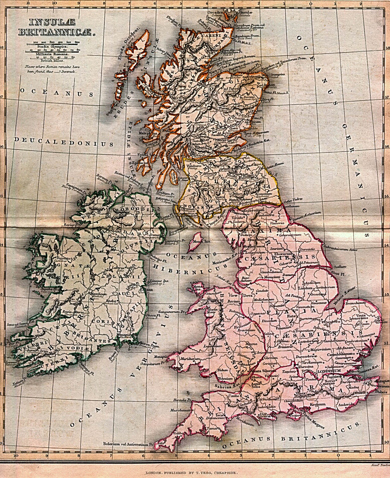
The County of Shropshire


This page has a selection of maps, as a basis for discussions about the location of the game. Some maps show castle locations (where there are castles, there are bothersome nobles), roads (nosy passersby), roman-latin nomenclature, etc.

A map of just Shropshire, showing Shrewsbury and the Strettons


Random Notes
PLANTAGENETS
Henry II 1154-1189
Richard I 1189-1199
John 1199-1216
Henry III 1216-1272
Edward I 1272-1307
Edward II 1307-1327
Edward III 1327-1377
